Demography of Bradford
Bradford, England is an ethnically and culturally diverse city. The City of Bradford metropolitan borough is the sixth most populous local authority district in the United Kingdom, and includes not only Bradford but also the towns and villages of Keighley, Shipley, Bingley, Ilkley, Haworth, Silsden, Queensbury, Thornton and Denholme.

Built-up area
The Office for National Statistics identifies "Bradford Built-up area subdivision", defined by its own algorithm,[1] as an area of 81.74 km2 (31.56 sq mi) with a 2011 population of 349,561 and a density of 4,280 people per square km.[2] It is a subdivision of the West Yorkshire Built-up Area.
Population
The City of Bradford's total population, according to the 2011 UK census, was 522,452. The population density was 1,428 people per square km.
Ethnicity
The following table shows the ethnic group of respondents in the 2001 and 2011 censuses in the City of Bradford.
| Ethnic Group | 2001[3] | 2011[4] | ||
|---|---|---|---|---|
| Number | % | Number | % | |
| White: British | 355,684 | 76.06% | 333,628 | 63.86% |
| White: Irish | 3,479 | 0.74% | 2,541 | 0.49% |
| White: Gypsy or Irish Traveller[note 1] | 433 | 0.08% | ||
| White: Other | 6,878 | 1.47% | 15,715 | 3.01% |
| White: Total | 366,041 | 78.27% | 352,317 | 67.44% |
| Asian or Asian British: Indian | 12,504 | 2.67% | 13,555 | 2.59% |
| Asian or Asian British: Pakistani | 67,994 | 14.54% | 106,614 | 20.41% |
| Asian or Asian British: Bangladeshi | 4,967 | 1.06% | 9,863 | 1.89% |
| Asian or Asian British: Chinese[note 2] | 896 | 0.19% | 2,086 | 0.40% |
| Asian or Asian British: Other Asian | 2,932 | 0.63% | 8,031 | 1.54% |
| Asian or Asian British: Total | 89,293 | 19.09% | 140,149 | 26.83% |
| Black or Black British: Caribbean | 3,038 | 0.65% | 3,581 | 0.69% |
| Black or Black British: African | 970 | 0.21% | 4,993 | 0.96% |
| Black or Black British: Other Black | 325 | 0.07% | 693 | 0.13% |
| Black or Black British: Total | 4,333 | 0.93% | 9,267 | 1.77% |
| Mixed: White and Black Caribbean | 2,611 | 0.56% | 4,663 | 0.89% |
| Mixed: White and Black African | 449 | 0.10% | 875 | 0.17% |
| Mixed: White and Asian | 2,926 | 0.63% | 5,677 | 1.09% |
| Mixed: Other Mixed | 951 | 0.20% | 1,764 | 0.34% |
| Mixed: Total | 6,937 | 1.48% | 12,979 | 2.48% |
| Other: Arab[note 3] | 3,714 | 0.71% | ||
| Other: Any other ethnic group | 1,061 | 0.23% | 4,026 | 0.77% |
| Other: Total | 1,061 | 0.23% | 7,740 | 1.48% |
| Total | 467,665 | 100.00% | 522,452 | 100.00% |
Notes for table above
- New category created for the 2011 census
- In 2001, listed under the 'Chinese or other ethnic group' heading.
- New category created for the 2011 census
 White
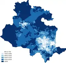
White White-British
 White-Irish
 White-Other
 Asian
Asian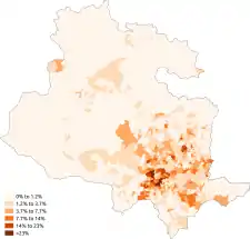 Asian-Indian
 Asian-Pakistani
 Asian-Bangladeshi
 Asian-Chinese
 Black
Black Black-African
 Black-Caribbean
 Other-Arab
Languages
The most common main languages spoken in the City of Bradford according to the 2011 census are shown below.[5]
| Rank | Language | Usual residents aged 3+ | Proportion |
|---|---|---|---|
| 1 | English | 424,527 | 85.31% |
| 2 | Punjabi | 19,842 | 3.99% |
| 3 | Urdu | 16,550 | 3.33% |
| 4 | Polish | 5,526 | 1.11% |
| 5 | Bengali (incl. Sylheti and Chatgaya) | 4,743 | 0.95% |
| 6 | Pashto | 3,580 | 0.72% |
| 7 | Gujarati | 2,638 | 0.53% |
| 8 | Arabic | 2,398 | 0.48% |
| 9 | Slovak | 2,162 | 0.43% |
| 10 | Kurdish | 1,275 | 0.26% |
| 11 | Pakistani Pahari (incl. Mirpuri and Potwari) | 1,048 | 0.21% |
| 12 | Latvian | 985 | 0.20% |
| 13 | Russian | 690 | 0.14% |
| 14 | Czech | 642 | 0.13% |
| 15 | Tagalog/Filipino | 640 | 0.13% |
| 16 | Persian | 592 | 0.12% |
| 17 | Italian | 564 | 0.11% |
| 18 | French | 443 | 0.09% |
| 19 | Lithuanian | 436 | 0.09% |
| 20 | Greek | 382 | 0.08% |
| Other | 7,945 | 1.60% |
Religion
The following table shows the religion of respondents in the 2001 and 2011 censuses in the City of Bradford.
| Religion | 2001[6] | 2011[7] | ||
|---|---|---|---|---|
| Number | % | Number | % | |
| Christian | 281,236 | 60.14% | 239,843 | 45.91% |
| Buddhist | 537 | 0.11% | 1,000 | 0.19% |
| Hindu | 4,457 | 0.95% | 4,882 | 0.93% |
| Jewish | 356 | 0.08% | 299 | 0.06% |
| Muslim | 75,188 | 16.08% | 129,041 | 24.70% |
| Sikh | 4,748 | 1.02% | 5,125 | 0.98% |
| Other religion | 996 | 0.21% | 1,686 | 0.32% |
| No religion | 62,226 | 13.31% | 108,027 | 20.68% |
| Religion not stated | 37,921 | 8.11% | 32,549 | 6.23% |
| Total | 467,665 | 100.00% | 522,452 | 100.00% |
 Christianity
 Islam
Islam Judaism
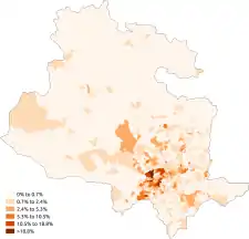 Hinduism
 Sikhism
 Buddhism
 Other religion
 No religion
See also
- Demography of West Yorkshire
- Demography of the United Kingdom
- Demography of England
- Demography of London
- Demography of Birmingham
- Demography of Greater Manchester
- List of English cities by population
- List of English districts by population
- List of English districts and their ethnic composition
- List of English districts by area
- List of English districts by population density
References
- "2011 Built-up Areas - Methodology and Guidance" (PDF). Office for National Statistics. 2013. Retrieved 7 October 2021.
- UK Census (2011). "Local Area Report – Bradford Built-up area sub division (E35001211)". Nomis. Office for National Statistics. Retrieved 7 October 2021.
- "2001 census - theme tables". NOMIS. Retrieved 17 June 2015.
- "Download:local authorities: county / unitary". NOMIS. Retrieved 17 June 2015.
- "Download:local authorities: county / unitary". NOMIS. Retrieved 17 June 2015.
- "2001 census - theme tables". Retrieved 17 June 2015.
- "Download:local authorities: county / unitary". NOMIS. Retrieved 17 June 2015.