Chondon
The Chondon (Russian: Чондон;[1] Yakut: Чондоон) is a river in the Republic of Sakha in Russia. It is 606 kilometres (377 mi) long, with a drainage basin of 18,900 square kilometres (7,300 sq mi).[2]
| Chondon Yakut: Чондоон | |
|---|---|
 Location in the Sakha Republic, Russia | |
| Location | |
| Country | Yakutia, Russia |
| Physical characteristics | |
| Source | |
| • location | Selennyakh Range |
| • coordinates | 69°48′35″N 137°55′48″E |
| • elevation | 640 m (2,100 ft) |
| Mouth | |
• location | Laptev Sea |
• coordinates | 71°14′25″N 138°9′41″E |
• elevation | 0 m (0 ft) |
| Length | 606 km (377 mi) |
| Basin size | 18,900 km2 (7,300 sq mi) |
| Discharge | |
| • average | 20 m3/s (710 cu ft/s) |
The Chondon mammoth was discovered in 2013 in the Chondon basin, at the feet of the Polousny Range, 66 km south-west of the village of Tumat. It had died at the age of 47 to 50 years.[3]
Course
The river begins in the northern slopes of the Selennyakh Range at an elevation of 640 metres (2,100 ft). It flows west of the Yana River across the Yana-Indigirka Lowland mostly among marshy areas.[4] It has its mouth in the Yana Bay of the Laptev Sea.[5]
The main tributaries of the Chondon are Buor-Yuryakh, with its source in the Kyundyulyun, Povarnya, Pravaya, Kiska, Tas-Yuryakh and Barsa.[4]
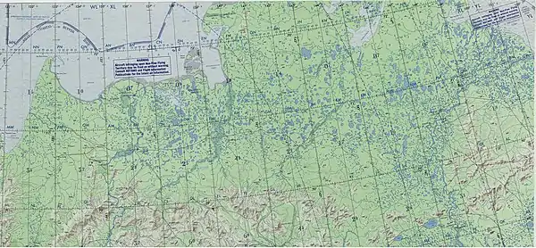 Yana-Indigirka Lowland map section |
References
- Словарь названий гидрографических объектов России и других стран — членов СНГ, Federal Service for Geodesy and Cartography of Russia, 1999, p. 433
- Russian State Water Register - Chondon River
- Всё о мамонтах (All about Mammoths)
- Chondon // Great Soviet Encyclopedia, in 30 vols. / Ch. ed. A.M. Prokhorov . - 3rd ed. - M .: Soviet Encyclopedia, 1969-197
- Google Earth