Amguema (river)
The Amguema (Russian: Амгуэ́ма, Chukot: Оʼмваам, O'mvaam;[1] in its upper course Вульвывее́м, Vulvyveyem[2]) is a stream located in Far East Siberia. It empties into the Chukchi Sea between Cape Schmidt and Cape Vankarem.[3] It is 498 kilometres (309 mi) long, and has a drainage basin of 28,100 square kilometres (10,800 sq mi).[4]
| Amguema | |
|---|---|
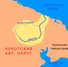
 Location of the Amguema River course | |
 | |
| Native name | |
| Location | |
| Country | Russia |
| Physical characteristics | |
| Source | |
| • coordinates | 68°49′N 177°24′E |
| Mouth | Chukchi Sea |
• coordinates | 68.2533°N 177.4239°W |
| Length | 498 km (309 mi) |
| Basin size | 28,100 km2 (10,800 sq mi) |
| Discharge | |
| • average | 285 m3/s (10,100 cu ft/s) |
Geography
The river flows roughly from SW to NE across the Chukotka Mountains. It belongs to the Chukotka Autonomous Okrug administrative region of Russia.[5] The Ekityki is the main, left-side tributary of the Amguema.[6]
Upriver there is the small town of Amguema, where about 600 mostly Chukchi people live.[7]
See also
References
- Russia. Topographic map Q-60-XI,XII
- Dictionary of names of hydrographic objects of Russia and other countries - members of the CIS (1999), p. 22
- Geographic Location
- Река Амгуема (Омваам, в верховье Вульвывеем) in the State Water Register of Russia (in Russian)
- Chukotskoye Nagorye / Great Russian Encyclopedia; in 35 vol.] / Ch. ed. Yu.S. Osipov . - M .: Great Russian Encyclopedia, 2004—2017.
- "Hydrographic and Environmental data" (PDF). Archived from the original (PDF) on 2007-10-29.
- Amguema Town
This article is issued from Wikipedia. The text is licensed under Creative Commons - Attribution - Sharealike. Additional terms may apply for the media files.